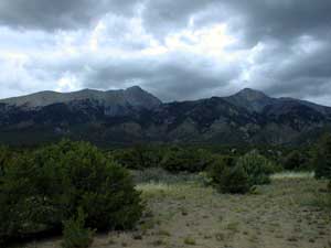
Blanca Peak Sep 12, '99
Steve Bremner and Sam the Wolfdog
| The route from Blanca Basin was once the standard route up Little Bear and also provides an easy route up Blanca, avoiding the difficult road to Lake Como. Unfortunately it has been closed for some years. Apparently the owners of the grant for that large area extending just north of the town of Blanca off U.S. Highway 160 denied access after problems with troublesome campers and hikers. The weekend before I had camped high at upper Winchell Lake after a successful ascent of Lindsey Mountain. From this high camp I had hoped to ascend the east ridge of Blanca. However, the next morning I turned back short of the actual ridge after coming on a more difficult bit of rock than I was unwilling to risk alone. Looking at the topo map it appeared an approach from the southern side of the ridge would be an easier grade. | |
 |
Gary Roach's excellent new edition of "Guide Book to Colorado's Fourteeners" mentions that the route from Blanca Basin is actually the easiest way up Little Bear, but is now closed. Ormes' "Guide to the Colorado Mountains" goes a bit further by describing access and the trail in case that policy is changed by future owners. Being a somewhat irreverant sort, I took up the challenge of figuring out how to breach this closed off patch of wilderness. |
Armed with the terse Ormes description and USGS topo maps to Blanca
Peak and Twin Peaks I set out on Saturday, September 11th from Colorado
Springs--of course driving my '59 Chevy with Sam the Wolfdog "dognapping"
in the back seat. It's about a three hour drive to the small town of Blanca
on US Highway 160 south of Blanca Basin. I followed Smith, then Cedar Road
north-northeast of the town in the direction of Arrowhead Lodge. The road
goes fairly straight, with one jog right then left again, until it reaches
a point where you can either continue straight on a 4-wheel drive road
or go right on a road not much better than 4-wheel. I went right and after
a mile or so came on the entrance to Arrowhead Lodge. Since the Ormes guidebook
said the 4-wheel track leading to the trail up Blanca Basin was half a
mile before the lodge I knew I was in the right vicinity. I turned around,
looking for a suitable place to "stash" my car. As I did so I noted a house
south of the road I was on that appeared to be the caretakers house. I
don't think there is actually a "Arrowhead Lodge"--at least not one occupied
on a permanent basis. I turned north up a rough road obviously not frequented
and parked about 100 feet up off to the side of the road.
| After assembling my pack and gear I set out around 4 P.M. under ominous skies for the 4-wheel drive road. Since I'd parked my car short of that road I thought it would be a simple matter to bushwack in the direction of where the road should be and thereby intersect with it. As I trudged through the juniper forest, with occasional cactus underfoot, a thunderstorm moved swiftly from west to east. Soon it began to rain and then big drops of rain splattered on me interspersed with hail. The lightning and the ensuing thunder reports indicated the storm was nearly directly on top of me. After 20 minutes I came on a road. Instead of going north in the direction of Blanca Basin it went east-west. I elected to follow it west. Just when I was about to completely give up on it and after it had been following alongside a barbed-wire fence along its northern side I noticed a "no trespassing" sign. Vandals had scratched on the sign "f-- you Honky!" and after a closer look I noted that a rough road extended north from the other side of the fence. Could this be the road leading to Blanca Basin? | 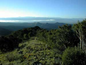 |
Crossing through the fence (and now definitely "Trespassing") I followed
along the 4-wheel road for half an hour until it came to an end before
a slight rise in the terrain. The choices now were right or left. Going
right ended quickly, so I went left and followed a fainter track until
I realized that couldn't be the way. In the distance to the north I noted
the valley I was aiming for was now much too far to the east. Backtracking
to the east, after reaching the dead end to the right I continued now bushwacking
in an easterly direction. Soon I came on a daunting cliff far beneath which
an exuburent brook rushed down to lower ground. This had to be Blanca Creek.
If so I was well off course. Looking east I noted what I thought was a
jeep track on the other side of the deep gully formed by the creek. My
new objective was to trek south to an easier creek crossing point, then
reach the jeep track. I could easily see my objective from this vantage
point, but I well knew that once I went below into the gully it would not
be so clear. Therefore I brought out my compass to measure the bearing
I would have to maintain to reach my goal. After finally emerging from
the gully I realized I had reached the end of the 4-wheel track described
in Ormes. I soon found the ruined cabin above which was the mine. I began
to hike further up the valley, only to be stopped by another downpour.
It was now nearly 7 P.M. so I decided to set up my tent. While setting
up the tent the rain became more persistent. I went inside quickly followed
by Sam before it really began to rain in ernest. After an hour the rain
stopped, but by that time I'd eaten dinner. My headlamp's battery was dead,
so since I couldn't read I dropped off around 8:30 that evening.
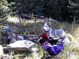
| Sam willingly slept in the tent that night--which I much prefer given his propensity to ferret out porcupines, skunks and other unsavory critters of the night. Doesn't he look like a "devil dog" with his red eyes? | 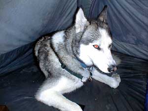 |
 |
Sunday morning we were up and about around daybreak. The storms of the previous evening were gone and the day looked promising. Packing up my gear I elected to bring it all with me until I definitely found myself on the trail. Ormes propounded the trail as starting to the left of the cabin ruin--this area was quite overgrown with no evidence of any trail at all. Bushwacking up to the ridge east of Blanca Creek proved to be the best course. Once on the ridge the going was easy enough. |
| Sam found himself a fine half of an elk rack. I attached it to my pack
as we continued along the ridge. Finally we intersected the old trail. Marked
by occasional cairns and red ribbon markers we now were on a clear
course. Not long afterwards I veered about twenty feet off trail and hid
my pack behind a large stone. I set the elk rack on the trail so I would
remember where I had left my pack. (Much later that day when we returned
Sam pulled me straight to the pack--evidence of his excellent memory. He
truly is a remarkable dog. I learn a lot just be observing him and his behaviours.)
I noted an excellent crop of chanterelle mushrooms in the vicinity of where I deposited my pack--on the way back I hoped to get a few for a mushroom feast. |
 |
 |
Following the cairns and the trail as it was we crossed Blanca Creek then ascended up and traversed a cliffy region west of the creek, continuing into the basin. If we were going to be climbing Little Bear we would have diverged from the trail and began to ascend the ridge. Instead we continued up to the basin. On the way we came on several cabin ruins of which the picture at left is one. I left my jeans there to dry, but since I lost the trail on our return they are still there hanging on a pine tree.. |
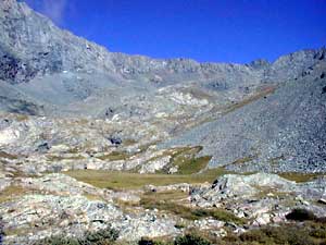
| . We reached the basin around 1000 that morning. A pair of deer reluctantly vacated their feeding ground. I had already seen much evidence of wildlife. Closing off large land grants to public access provides them a safe haven. A definite positive aspect of these atavistic remnants of the Spanish rule. I now had a decision to make--Climb Little Bear or Blanca. At that point I realized realistically I would only make it up one or the other that day. Ascending the east ridge of Blanca looked quite straightforward, so after plotting my route I started off up scree slopes. |  |
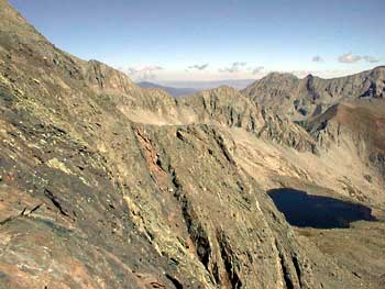 |
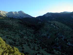
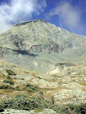
After nearly an hour I reached the ridge. I had a ways to travel--Blanca loomed far in the distance. The going along the ridge was difficult and a couple of times I had to backtrack to help Sam find an easy route through the talis. The picture at left shows the route up Blanca's east ridge from Winchell Lake that I had attempted the prior weekend. I had ascended the ramp marked by the more orange rock, but hesitated to make the move from there to the rock on the ridge. I was alone and without even a helmet and it was a bit too exposed so I had turned back. |
| The view from Blanca's ridge shows Lindsey to the right and Iron Nipple, both of which I had climbed the previous weekend. | 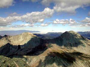 |
 |
Reaching Blanca's summit shortly before 1300 I was faced with the prospect of running out of daylight. As long as I was going up Blanca I had hoped to bag Ellingwood point as well. The choice was to skirt close to the ridge along a class 3 route or drop down close to Crater Lake and go up an easier class 2 ascent. I chose the latter as Sam sometimes has difficulties on rock and I thought it would be faster. It wasn't and when the hour reached 1400 I decided to turn back. Having nearly reached Crater Lake I now had ascend Blanca again! Not easy. |
| Up and over Blanca for the second time this time instead of going along the tortuous ridge after descending the summit pyramid I dropped directly into Blanca Basin. Far below I could see the ruins of a couple cabins and mines. When I finally reached them there was the usual left over debris of rusting tin cans and even a mostly intact cast iron stove. I gathered a few of the tin cans to at least make a positive effect on the scene. This route proved much easier than the ridge and I would recommend it for an ascent of Blanca as well. | 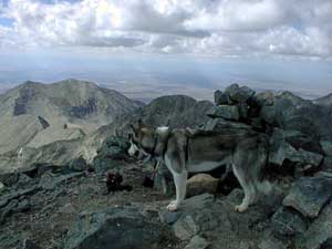 |
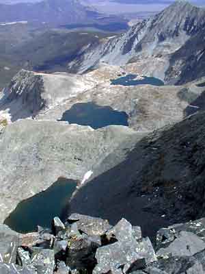 |
.The view at left shows all the Winchell Lakes. The previous weekend I camped at the middle. After the sun dropped below the ridge it got quite cold there. As I moved down the basin it was now a race against time. I knew it would be close whether or not I made it out before the lights went out. Past a swampy area the on-again off-again trail marked by occasional cairns started up once more. After a mile or so I lost the trail and even after much searching could not find it. My only choice was to continue to move lower keeping Blanca Creek to my left. Problem was this was a region of cliffs and the trail obviously was created to navigate the easiest route through. Seemingly miraculously after an hour of rough going I came on a cairn and was back on track. So this was the second time I got lost. There were two more to come and it was already nearly 1700. |
Just before crossing Blanca Creek the cabin ruins mentioned in the guide book and marked on the USGS topo map appeared. I'd not found them on my way in, having momentarily lost the trail. To climb Little Bear the best route is to leave the trail in the vicinity of the cabin ruins and begin ascending the ridge--initially through timber.
Crossing the creek while moving always lower the creek dropped below us and we reached a ridge above the creek. Running much of the way we made excellent time and soon reached my pack. Though I would later regret it in the interest of time I left the bountious crop of chanterelles, donned my pack and the elk antler and quickly continued down the ridge. Above the draw below which were the cabin ruin and mine I had camped next to the previous night I began to descend. That morning I had ascended to the ridge, but now with the ruin site in view dropping lower was the obvious course.
Finding the 4-wheel drive road I was now on new ground. We had to breach the fence after the ruins to move out of private property, then not 100 yards later the road coursed back to the other side of the fence. This time we remained safely in private lands for a mile or more after which apparently someone had cut the fence where the road moved once again into public land. Unsure of my course now and with the sun nearly set I continued along the road. My gut feeling was that I now should leave the road and move left. Instead I continued along the road. Finally I reached an intersection where to the left the road stretched all the way to the town of Blanca. I started down that way but after walking ten minutes I had second thoughts and decided to turn around--thinking that the 4-wheel drive road on my topo map led straight to main road I'd left my car on. There was no right angle turn to the left. Sam to his credit dug in and only with great reluctance did he go my course. Reaching the intersection again I went left and as it grew ominously darker I once again rethought my course and decided my initial instincts were correct. I retraced my steps, turned right again in the direction of Blanca. AGAIN I had second (third) thoughts and retraced my steps to the intersection, this time going back in the direction of the Basin. Looking south I could see a lamp post that I surmised to be either from "Arrowhead Lodge" or from the caretaker's house that I had parked not far from. I aimed for that lamp, now moving cross-country along a fence. Reaching a dirt road I continued along it until I came on the Arrowhead Lodge gate. Now I knew where I was. I now had to retrace my steps again before I came on my hidden car that I had passed within 30 feet of nearly an hour before as I hiked towards the lamp post. Okay that's three times I was lost. One more to go. I spent half an hour driving around in circles before finding my way out of the maze of roads to the highway. I didn't finally get home until 0130 Monday morning and I had to be at work by 0730.