 From Flagstaff to Kingman, Arizona was easy Interstate driving of around 150
miles. Close to Kingman I turned the wheel over to Laila so I could get a little
rest.
From Flagstaff to Kingman, Arizona was easy Interstate driving of around 150
miles. Close to Kingman I turned the wheel over to Laila so I could get a little
rest. Steve
Bremner, Laila Hughes,
Sir Vidia the Shadow,
and Sam the Wolfdog
August 27th, 2000
Boundary
Peak
High Point of Nevada
13,140'
After climbing Humphreys Peak, the high point of
Arizona, Laila and I continued our Southwest "highpoints" westward and to the
north, past Las Vegas <aka Sin City> to the isolated high point of Nevada,
Boundary Peak. It was a LONG drive.
From Flagstaff to Kingman, Arizona was easy Interstate driving of around 150
miles. Close to Kingman I turned the wheel over to Laila so I could get a little
rest.
From Kingman we turned north on Highway 93, a good fast road, but it really bottlenecked when it crossed the Hoover Dam, and traffic came to a crawl.
Eventually we were approaching the monstrous epitome of runaway growth, Las Vegas at an unfortunate hour, around 5 P.M. We hit on a plan to stop at one of the big casinos and get one of their cheap (and excellent) buffets. As long as traffic was moving reasonably fluidly we kept going as long as possible, not wanting to get off the freeway only to get mired in traffic and stoplights and <well>, lost.
We were all the way into Northwest Las Vegas when it began to look like we
might run out of casinos pretty quickly. So we turned off Highway 95 and aimed
for the business route. This was a mistake as we quickly were in gridlock. Half
an hour later a casino came in sight and happily they advertised a seafood buffet.
 I
love to gamble and Laila agreed to let me sit at a blackjack table for five
minutes. By the time the time was up I had won $20! The dinner came to about
$27 for both of us. I made up for the difference as we were leaving. While Laila
went to the powder room, I threw some spare nickels into a slot machine and
got a grand pile of nickels worth $11.
I
love to gamble and Laila agreed to let me sit at a blackjack table for five
minutes. By the time the time was up I had won $20! The dinner came to about
$27 for both of us. I made up for the difference as we were leaving. While Laila
went to the powder room, I threw some spare nickels into a slot machine and
got a grand pile of nickels worth $11.
Back to the truck by seven, it was getting dark. We still had a long ways to drive. I just wanted to get as close to the trailhead as possible by midnight or so, then pull off to the side of the road to sleep in the back of the truck.
Turning off 95 on the lonely 266 we drove past Lida before finding what I thought must have been an uninhabited dirt road. As we set up the mattress in the back of the truck around 1 A.M. we heard a dog barking a ways farther up the road. It continued to bark stupidly for over an hour. In the morning light as we awakened we saw a house 100 yards from where we had stopped.
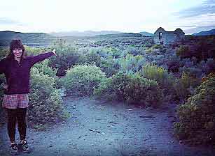
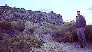
Not far from where we had stopped that night we came on a ghost town. Solidly
built with stones it should be a monument for some time--much like the old castle
ruins of Germany. 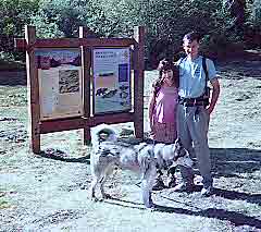 The
road took us briefly into California and into a beautiful irrigated valley with
a bountiful harvest of wheat.
The
road took us briefly into California and into a beautiful irrigated valley with
a bountiful harvest of wheat.
Soon back in Nevada the landscape returned to stark and desolate. Just before the 773 cutoff for Tonopah there is an unmarked dirt road you go left on. This is about a mile or so past an industrial looking building on the right. Here is where you get set for a long drive on rough road, though passable for a car. The scenery is spectacular as you switchback up into ever higher country.
After about 11 miles we turned right and followed the road as it curved left.
The old B & B Mine was to our right. When the road turned red we turned
right. Passing a small pond to our left (on the way back it was populated with
fishermen) the trailhead was about a mile further up the road. Sagebrush encroached
on the road in this last mile and WILL scratch your car! 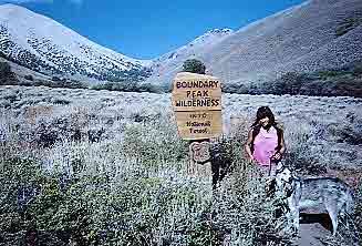 At the trailhead is an informative sign for the trail and our first indication
that we were "on track" and in the right place!
At the trailhead is an informative sign for the trail and our first indication
that we were "on track" and in the right place!
We talked with a man who was waiting on his partner to complete the climb. The description I had read recommended going to the saddle (just to the left of the sign in the picture at right). He said his partner was going to the left of the hill in the left of the photo, a way he recommended at least using for our descent. I don't like loose scree climbs, so we aimed for the saddle.
Once past the Boundary Peak Wilderness sign the trail became on again off again.
Mostly off. We picked our way through the sage brush. I was glad we were wearing
long pants. To our left we noticed a pair moving very slowly. They were definitely
off course, going on what looked to be a course to directly ascend the hill
to the left. 
We stuck to our strategy and plodded up to the saddle--a surprisingly long ways. As we moved up the saddle we saw the hapless couple barely gaining any headway. I told Laila they would never make it. Later after we had completed the climb we came back to the car at about the same time as they did. Sorely out of their element they had not made it much further than where we had seen them.
At the saddle we stopped for repast and were surprised to have an Austrian woman come up on us. She came up from the "California side" from the Northwest. Said it wasn't too bad. She took our picture and I practised my German with her for a while. Laila chided me later for wasting too much time talking with her.
From the saddle we gained 1200' of elevation in about half a mile. From that
vantage point the peak came into view. 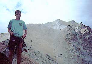 The climb became easier and most enjoyable from there on. The trail is obvious.
Thunderstorms loomed on the horizon and we quickened the pace. It took us just
over two hours to reach the summit from the trailhead. Due to the worsening
weather we decided to forgo climbing Montgomery Peak, about a mile distant in
California.
The climb became easier and most enjoyable from there on. The trail is obvious.
Thunderstorms loomed on the horizon and we quickened the pace. It took us just
over two hours to reach the summit from the trailhead. Due to the worsening
weather we decided to forgo climbing Montgomery Peak, about a mile distant in
California.
The descent was down the scree path as recommended by the man
at the trailhead. A wise choice. 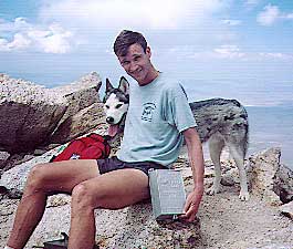 Soon we had lost the bulk of the elevation and were into the Trail Canyon Valley.
A lone wild stallion browsed the sage directly in our path. Holding the dogs
tight we tried to move above him so as not to disturb him. He moved out of our
way nevertheless. We looked back later and were happy to see he had moved back
to his accustomed position.
Soon we had lost the bulk of the elevation and were into the Trail Canyon Valley.
A lone wild stallion browsed the sage directly in our path. Holding the dogs
tight we tried to move above him so as not to disturb him. He moved out of our
way nevertheless. We looked back later and were happy to see he had moved back
to his accustomed position.
Now we had another very long drive ahead of us to get back to Laila's home in Salt Lake City. We listened to John McPhee's excellent book "Basin and Range", describing the geology of Nevada. As we drove across Nevada the title of the book became like a rythym, Basin and Range, Basin and Range. The basin's dry and desolate, the ranges magnificent and wild. Nevada looks like a great state to explore. With mountain ranges still forming as recently as 1915 (!) it is not a very propitious state in which to situate a nuclear plant for instance.
We camped that night in a range close to the Utah border, then the next morning after driving north of highway 6 up the basin in the direction of the Mt Moriah Wilderness, we turned right to the mountains on a dirt road. Just before the mountains rose from the valley floor we stopped and changed into running clothes and went on a trail run for about an hour.