Crestone
Needle
17 Jul 99
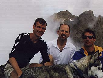
Steve Bremner, David French,
Greg Zoellick,
and Sam the Wolfdog
|
 Dave
French and I had been planning this trip for a couple of months, but we
both had a busy schedule for this summer--me running marathons and he
making expeditions to Yosemite and Mt Hood in Oregon. We finally set aside
this weekend to climb the Crestones. Dave
French and I had been planning this trip for a couple of months, but we
both had a busy schedule for this summer--me running marathons and he
making expeditions to Yosemite and Mt Hood in Oregon. We finally set aside
this weekend to climb the Crestones.
I met Greg Zoellick
a couple of weekends before while climbing Mt Sneffels. He kept pace with
me to the top and afterwards we made it a doubleheader by climbing Wilson
Peak that afternoon.
|
|
 I
told Greg that Dave and I would be starting out from lower South Colony
Lake early Saturday morning and that if he wanted to meet us that we'd
be on the north side of the lake. I
told Greg that Dave and I would be starting out from lower South Colony
Lake early Saturday morning and that if he wanted to meet us that we'd
be on the north side of the lake.
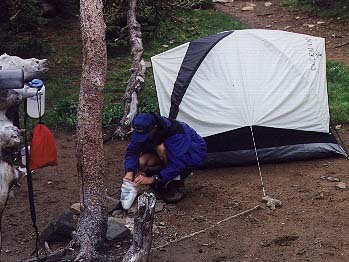
The jeep road into
South Colony Lakes trailhead is one of the roughest in Colorado, and we
were forced to park Dave's 2-wheel drive Toyota only about a mile up the
road. The rest of the four miles up road with full packs was a labor,
but by Friday mid-afternoon we reached the South Colony Lakes and set
up camp.
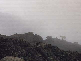
Just in time, because
it proceeded to rain pretty hard. We hunkered down in the tent and napped
and read until it ended after about an hour. When we emerged from our
hole to greet the mists and fog we considered our route for the next morning.
|
|
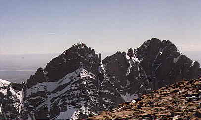 I
took the picture at left in mid-May when I climbed Mt Humboldt--winter
snows still clung to the sides of Crestone Needle(left) and Peak (right).
The route we would be taking up Crestone Needle in the morning began up
to the left saddle at the base of the summit pyramid on the Needle. It
looks steep and difficult in the photo, and it looked steep and difficult
from lower South Colony Lake that afternoon in July. Dave and I set out
on a reconnaissance tour to see just how hard it would be. I
took the picture at left in mid-May when I climbed Mt Humboldt--winter
snows still clung to the sides of Crestone Needle(left) and Peak (right).
The route we would be taking up Crestone Needle in the morning began up
to the left saddle at the base of the summit pyramid on the Needle. It
looks steep and difficult in the photo, and it looked steep and difficult
from lower South Colony Lake that afternoon in July. Dave and I set out
on a reconnaissance tour to see just how hard it would be.
The climber's trail
skirts the left lower side of lower South Colony Lake, then follows a
rising traverse across scree aiming for the notch, Broken Hand Pass. After
crossing a couple of short snow fields the track climbs steeply, with
a bit of hand and foot scrambling directly to the notch. Sam the Wolfdog
managed the scramble unassisted. We continued on the trail through rock
scrambles mixed with grassy meadows for about fifteen minutes, briefly
considering continuing to go ahead and climb it that evening. Concerned
about running out of daylight and the chance of the storm returning we
decided to wait until the next day, turning and retracing our steps to
camp.
|
 The
next morning we were hiking to the pass again around 0530. With no sign
of Greg we assumed he wasn't going to make it. Wrong. As we neared the pass
we heard him calling as he rapidly scrambled up the scree slope from far
below. It didn't take him long at all to catch up to us. Greg is a strong
climber. The
next morning we were hiking to the pass again around 0530. With no sign
of Greg we assumed he wasn't going to make it. Wrong. As we neared the pass
we heard him calling as he rapidly scrambled up the scree slope from far
below. It didn't take him long at all to catch up to us. Greg is a strong
climber. |
|
 In
the clouds and with limited visibility we followed the climber's trail
as it ascended just left of the ridgeline. At a notch, Sam had difficulty
making a short rocky descent, but was able to search out an easier route.
At the base of the apparent couloir mentioned in the guide book (Dawson's)
we began the class 3 climb, described as "the longest sustained hand
and foot climbing of any of the standard fourteener routes". In
the clouds and with limited visibility we followed the climber's trail
as it ascended just left of the ridgeline. At a notch, Sam had difficulty
making a short rocky descent, but was able to search out an easier route.
At the base of the apparent couloir mentioned in the guide book (Dawson's)
we began the class 3 climb, described as "the longest sustained hand
and foot climbing of any of the standard fourteener routes".
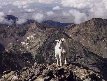
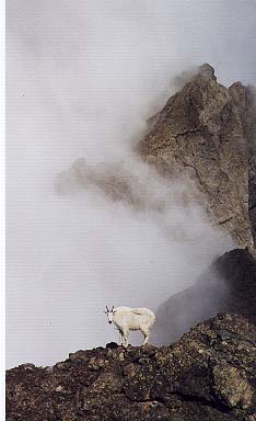
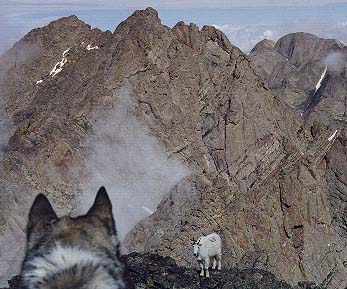
Sam the wolfdog gamely
scrambled up the rock, only requiring occasional, limited assistance.
Soon we met the mountain goat who would be our companion until we left
the peak. Sam attempted to chase it a couple of times as he grew more
confident maneuvring on rock.
|
 Greg
and I moved quickly up the couloir, missing the spot where the guide
book says the easier route goes left into a neighboring couloir. Staying
in the first couloir was easy enough, so we marched on up to the summit. Greg
and I moved quickly up the couloir, missing the spot where the guide
book says the easier route goes left into a neighboring couloir. Staying
in the first couloir was easy enough, so we marched on up to the summit.
After half on hour
of lounging up top we grew concerned about Dave. We called down into
the mists, but got no response. Finally he heard us and responded. Not
long afterwards he too reached the summit.
We briefly considered
the ridge to Crestone Peak, but with the dog along that was not feasible.
|
|
 We
followed a well-worn track down a gulley directly below the summit Soon
enough we realized that we were off track and would need to traverse across
to our left. Not wanting to retrace our steps we continued to descend
while scouting out possible routes left to the neighboring and easier
couloir. We
followed a well-worn track down a gulley directly below the summit Soon
enough we realized that we were off track and would need to traverse across
to our left. Not wanting to retrace our steps we continued to descend
while scouting out possible routes left to the neighboring and easier
couloir.
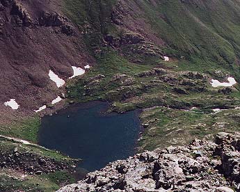
We were now going
down class 4 rock, and faced with the prospect of descending all the way
to Cottonwood Lake--a daunting proposition. It could get hairy.
Ultimately, we found
our escape hatch, emerging at the base of the couloir--Sam with some great
experience under his collar.
|
|
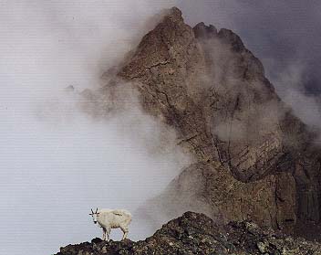
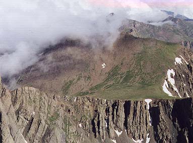 At
right is the Bear's Playground from Crestone Needle's summit. Behind the
clouds and some distance east is Kit Carson and Kat Carson peaks. The
next day we were up and on the Bear's Playground, continuing along the
east ridge up and over both peaks. At
right is the Bear's Playground from Crestone Needle's summit. Behind the
clouds and some distance east is Kit Carson and Kat Carson peaks. The
next day we were up and on the Bear's Playground, continuing along the
east ridge up and over both peaks.
|
fourteeners