 After
spending entirely too long on Veteran’s Day (Thursday) purchasing a ’97 Ford
F-150 4WD from a local dealership, I finally was on the road at 4 P.M. My initial
destination--the town of Crestone, CO on the western slope of the Sangre de
Christo range. From the outskirts of this quaint out-of-the-way town (12 miles
down a dead end road from highway 17) I proceeded south into the Baca Grande
Chalets on Camino Baca Grande towards the Cottonwood Creek trailhead. After
5.6 miles continuing straight (undistracted by the many side roads) I turned
left at a T intersection and in 100 yards I came to Cottonwood Creek. Here I
parked my newly acquired vehicle and prepared to sleep in it for the first time.
Not as comfortable as my ’59 Chevy—they don’t make cars (or trucks) as wide
as they used to.
After
spending entirely too long on Veteran’s Day (Thursday) purchasing a ’97 Ford
F-150 4WD from a local dealership, I finally was on the road at 4 P.M. My initial
destination--the town of Crestone, CO on the western slope of the Sangre de
Christo range. From the outskirts of this quaint out-of-the-way town (12 miles
down a dead end road from highway 17) I proceeded south into the Baca Grande
Chalets on Camino Baca Grande towards the Cottonwood Creek trailhead. After
5.6 miles continuing straight (undistracted by the many side roads) I turned
left at a T intersection and in 100 yards I came to Cottonwood Creek. Here I
parked my newly acquired vehicle and prepared to sleep in it for the first time.
Not as comfortable as my ’59 Chevy—they don’t make cars (or trucks) as wide
as they used to.
Next morning Sam the Wolfdog and I began hiking up the Cottonwood Creek Trail
at 0530. The trail was quite good for the first hour (3 miles?) at which time
we came on a large cabin ruin on our right. 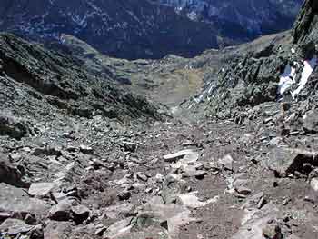 From
here on the trail was poor. Anticipating the trail going left and up to Cottonwood
Lake I turned left too early on a spur trail. This trail actually only led to
a horse camp site next to the trail. However, spotting a cairn beyond the site
I thought it may still be the trail I sought. This was the only cairn I would
see as I proceeded undaunted upward and onward in the direction of the Crestones.
I was left of the trail, and I knew that, but I also knew that if I continued
in an upward direction, generally north, that I could always traverse east and
connect up with the trail.
From
here on the trail was poor. Anticipating the trail going left and up to Cottonwood
Lake I turned left too early on a spur trail. This trail actually only led to
a horse camp site next to the trail. However, spotting a cairn beyond the site
I thought it may still be the trail I sought. This was the only cairn I would
see as I proceeded undaunted upward and onward in the direction of the Crestones.
I was left of the trail, and I knew that, but I also knew that if I continued
in an upward direction, generally north, that I could always traverse east and
connect up with the trail.
The going was arduous, but not overly difficult. After 1500 feet of elevation
gain we came into the basin below Crestone Peak--our route ultimately more direct
than if we had found the true trail.
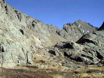 At
this point I took out the guide book and topo map to study the rocky faces of
the Crestones. Only after some reflection was it apparent which of the multitude
of jagged peaks along the horizon was Crestone Peak. Identifying the "red"
couloir (there was nearly no snow on the south side the Crestones) was the key
to the route I’d planned. I also was able to trace the Crestone Needle to Peak
traverse route. For my intended route, the guide book recommended going to the
right of the couloir and scrambling up Class 3 rock before the terrain naturally
led one into the couloir. When I started up the route cairns marked the easy
way. The route was "doggable"—i.e., Sam had little problem!
At
this point I took out the guide book and topo map to study the rocky faces of
the Crestones. Only after some reflection was it apparent which of the multitude
of jagged peaks along the horizon was Crestone Peak. Identifying the "red"
couloir (there was nearly no snow on the south side the Crestones) was the key
to the route I’d planned. I also was able to trace the Crestone Needle to Peak
traverse route. For my intended route, the guide book recommended going to the
right of the couloir and scrambling up Class 3 rock before the terrain naturally
led one into the couloir. When I started up the route cairns marked the easy
way. The route was "doggable"—i.e., Sam had little problem!
Atop the peak conditions were heavenly--the time 1000, the temperature 42F
and the wind maybe 7 MPH. The sun was shining and the views extended from the
Blanca group to the south, to Pikes Peak to the NE, and the San Juans to the
west. We lingered for half an hour just basking in the perfect glorious conditions
before resuming the downward climb.  Four
and a half hours it had taken us to reach the summit from the trailhead. To
reach the trailhead was again four and a half hours, even though it was downhill--an
indication of how difficult the route finding turned out to be.
Four
and a half hours it had taken us to reach the summit from the trailhead. To
reach the trailhead was again four and a half hours, even though it was downhill--an
indication of how difficult the route finding turned out to be.
The "true" trail on the way back, though initially easy enough, was
soon difficult to follow. There are a a series of cliffy expanses where the
trail is simply not there. One must do one’s best to lose the required elevation.
Keeping the creek close to my left I knew I was on track and soon came on a
well worn path and a few consecutive cairns. This fortuitous happenstance was
shortlived, however, and once again we were crashing through cliffy terrain
and problem-solving on how to drop elevation through treacherous ground. Traversing
right (west) I eventually reached the route I’d ascended that morning and dropped
easily to the trail on Cottonwood Creek, ultimately reaching my vehicle by 3
P.M.
A relatively early return was key to my next endeavour, namely to climb Mount
Adams, Challenger Point, and Kit Carson Peak the next
day (Saturday). From Cottonwood Trailhead I drove about ten miles, through the
town of Crestone and then east into the National Forest and to the Willow Creek
trailhead.Though I didn’t have enough daylight (sun now sets at 5 P.M.) to reach
Willow Lake, I was able to assemble my pack and gear to hike for half an hour
up the trail where I established camp at 4:40 P.M. on the Willow Creek Trail.
fourteeners