After returning
to my truck from El Diente around 5:30 P.M. on Sep 2nd, our next problem to
solve was how to get in the Chicago Basin trio of fourteeners, Eolus, Windom,
and Sunlight before the end of the Labor Day weekend. The drive back to Colorado
Springs would be six hours plus, the backpack in to Chicago Basin was 15 miles
one way, on top of that there were three fourteeners to go up. We had put
off climbing these fourteeners because they are so remote. Now that we had
come all this way we wanted to get them done.
On
the way towards the Purgatory trailhead we stopped in the "True Grit Cafe"--one
of Ridgway's claims to fame is having been the locale for the filming of the
John Wayne movie "True Grit". We went there on the recommendation of a local.
I was disappointed though with the Vegetable Stir Fry. A portly gentleman sporting
a cowboy hat sat next to us at the counter. He tried to start a conversation,
"Did you know there are more than 20 mountains over 12,000 feet in Colorado?
I counted them on the map." Then later, "I get up at 5 A.M. every morning, by
6:30 I have my breakfast steak and by noon by golly I'm hungry again." By the
looks of him he would be well off doing something about that hunger of his.
Leaving
Ridgway less fortified than I had hoped for we headed down highway 550. The
fifteen mile backpack (in and out) was nagging at me. I didn't so much mind
fifteen miles in, but I knew that the hike out would be agony. Normally climbers
take the Durango-Silverton train to the Needleton stop cutting a good ten miles
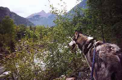
off the backpack from the road. The train doesn't allow dogs though and with
Sam the Wolfdog along we were stuck with the long backpack.
Or were we?
As we drove down the highway we began to brainstorm. "How about we drive to
Durango, get a hotel, and in the morning Jonathan, you take the train to Needleton
with our packs, and I run the trail with Sam to Needleton. I can do it in
2 hours--about the same time as the train will take!" Great plan! Driving
in to Durango we started seeing that all the hotels and motels had NO VACANCY
signs up, also a propensity of motorcycles parked in each of their parking
lots. Further in to town we saw the banners, "Welcome, Iron Horse Bikers!".
The entire town was filled with bikers. Not a hotel room for miles. Not to
worry, we headed out of town to the National Forest, pulled the truck over
to the side of the road and under clear skies inflated a mattress in the back
and slept out under the stars. Cheaper and much less complicated besides.
Next morning
we were fortunate to get a spot on the train leaving at 8:15 A.M. for Jonathan
and after I grabbed some Java and a croissant I drove up to the Purgatory
Trailhead.
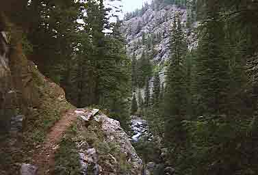
The
trail started off by immediately dropping about 800' in elevation over a mile
or so. Not a very propitious beginning, not to mention ending the next day!
A cursory look at the trail on the topo map had led us to believe the trail
was "flat". It was not flat. Instead of following the river proper the trail
climbed high above the river before returning to its lower levels twice before
finally reaching the Animas River 3.7 miles later. This section of the trail
had taken me 45 minutes. Now I would spend the next twenty minutes trying to
find where the trail continued. Finding the bridge over the river took ten minutes
as the trail suddenly showed three alternatives, none marked in any way. I took
the most well-worn trail and after that soon disappeared tried the next well-worn
trail. Finally I just hiked on down to the river and looked for the bridge.
After
crossing the bridge there was a sign saying, "Cascade Wye" and pointing right.
With no other alternative sign I assumed this must be the right way. Wrong again.
Wandering on down the non-trail I soon came on railroad tracks that dead-ended
by a large enclosed gazebo, picnic area. I guess this was "Cascade". The tracks
led out to the main tracks and after orienting myself with map and compass I
realized if I just hiked on the tracks I would run into the correct trail. This
I verified with a camper I noticed approaching. He told me "hike on down the
tracks and just before crossing the river the trail goes to the right, it's
an old wagon road. It's six miles to Needleton from there." Well, I had thought
it was five according to the guide book. Later when I reached the junction it
read seven miles back to Cascade. I think six miles is about right as it took
me about an hour to run the distance.
About
a mile past the bridge we came on a cabin by the river to our left. Right about
that time the train went noisily by tooting its whistle and blowing out lots
of coal dust--not moving very quickly at all. In fact Sam and I at a healthy
clip almost held our ground. I waved, but Jonathan wasn't looking I later learned.
The train was due to Needleton at 10:50 and I calculated that by the time Jonathan
had retrieved the packs and hiked out to the trail junction it would be 11:20.
This was now my "goal time". I made it to the junction at 11:19, 30 seconds
before Jonathan arrived!! We didn't waste time, quickly getting under way it
took us just under two hours on the excellent trail to reach our camp site as
high as you can go before reaching the closed area. Above timber line is closed
for obvious preservation reasons.
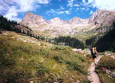
After setting
up the tent and hanging our food we were moving up to the peaks just after
2 P.M. We wondered if we might be able to bag all three that same day. We
could have if not for difficulties with Sam the Wolfdog.
This is wilderness,
far from the sound of a car on the highway. For this reason it is a very popular
place. We saw many hikers and climbers, and at least three rangers. As we
hiked up to Twin Lakes we met someone coming down saying, "Is that Sam the
Wolfdog?!" "You must be Steve, and Jonathan". It was John Prater who had read
some of my trip reports and with whom I had corresponded by email. He was
coming down from doing all three in eight hours. A darn good time. This was
when we first thought we had a good shot at getting them all done that day.
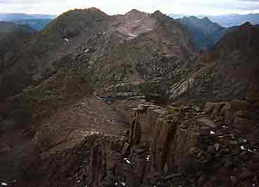
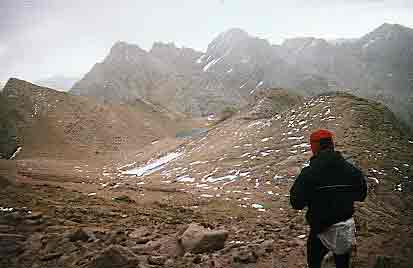
Our
first peak would be Eolus. After reaching Twin Lakes in half an hour from camp
we moved left on the climber's trail ascending into the basin below Eolus. The
cairn-marked route continues to a spine between North Eolus, a 14,000 foot subpeak
of Eolus and Eolus proper. We continued to follow cairns too far--past the spine
and into the next high basin with a small alpine lake. The correct course is
to ascend the spine to the saddle between N. Eolus and Eolus. Not taking time
to consult maps or compass we ended up to the right of N. Eolus, thinking it
was Eolus Jonathan went up it. Finding no register he yelled back down to me
that Eolus must be the peak far to the right. I was having troubles getting
Sam to go up the class three rock. He was spooked from our off-route ascent
of El Diente the day before and would have none of anything of difficulty. I
coaxed him along skirting the summit of N. Eolus and aimed for the saddle and
the famed "cat walk", a flat two-foot wide ridge walk with exposure to either
side connecting N. Eolus to Eolus. I have to say that it was a "cake walk",
really not a big deal at all. For Sam though it was the last straw. He moved
down the mountain. Rather than lose 300 feet elevation to retrieve him at this
point I moved up the mountain to join Jonathan on the summit around 4:30. We
quickly moved on down the mountain returning to Twin Lakes around 5:15.