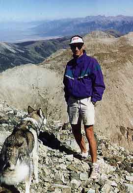
Ascent of Mount Lindsey, Iron Nipple and Point 13,828, Colorado
Sep 4, 1999
By Steve Bremner and Sam the Wolfdog
| Taking off a bit early from work Friday afternoon I drove to the Sangre de Christos and the phenomenally beautiful Huerfano River Valley. From Gardner it is over 22 miles of dirt road to the trailhead. The last 7-8 miles are quite rough, but I made it to 300 yards from the trailhead with my '59 Chevy only bottoming out once! | |
There are plenty of car campsites along the Huerfano (orphan boy in Spanish), but I went up above the river on the last mile of road before the trailhead. I had to walk back down the road to get water, so in retrospect I would have been better off camping down by the river.
 I got a late start the next morning as I enjoyed my new 0F bag I had just
bought on sale at Grand West Outfitters, not hitting the trail until 0720. The
going along the Huerfano is pretty level the first mile or two as it goes
along an old 4-wheel drive track. Then with no markings to indicate which
direction, if you're going to ascend Lindsey you just take the track going
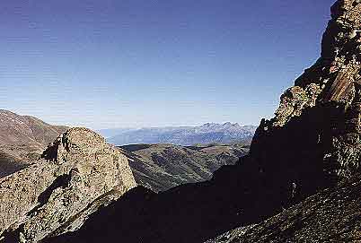
up and to the left. Climbing steeply the trail soon reaches a high meadow
with a splendid view of Blanca's north face. I stopped to take a picture,
but my camera battery was too cold and I never did get that shot. With that
stop and another one at the top of the saddle I played leap frog with about
six other climbers as I passed them when moving while they in turn passed
me when I delayed. I hauled all my overnight gear up to 13,000 feet as I
was still undecided on where I was going to camp that night and just what
mountains I would be going for on the following day. Dropping it there on
the 13,000 foot ridge I turned my sights on Lindsey, now in view as an imposing
pyramid to the east.
I got a late start the next morning as I enjoyed my new 0F bag I had just
bought on sale at Grand West Outfitters, not hitting the trail until 0720. The
going along the Huerfano is pretty level the first mile or two as it goes
along an old 4-wheel drive track. Then with no markings to indicate which
direction, if you're going to ascend Lindsey you just take the track going
up and to the left. Climbing steeply the trail soon reaches a high meadow
with a splendid view of Blanca's north face. I stopped to take a picture,
but my camera battery was too cold and I never did get that shot. With that
stop and another one at the top of the saddle I played leap frog with about
six other climbers as I passed them when moving while they in turn passed
me when I delayed. I hauled all my overnight gear up to 13,000 feet as I
was still undecided on where I was going to camp that night and just what
mountains I would be going for on the following day. Dropping it there on
the 13,000 foot ridge I turned my sights on Lindsey, now in view as an imposing
pyramid to the east. |
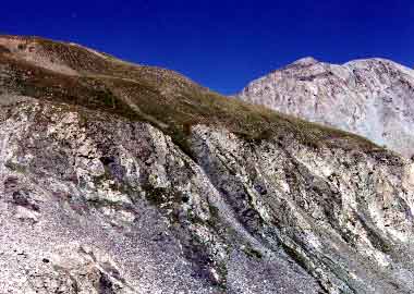
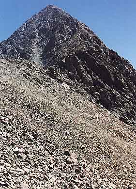 Once ascending the actual pyramid I donned my helmet as there was a lot
of loose stuff and the going is rather steep. Sam the Wolfdog had no problems
though-- it was definitely class "2+". Once over the false summit the going
was quite easy over the last 200 yards to the actual peak. One fellow passed
me on his way down, and on the summit I met Steve and ? Kaiser. (For some
reason I remember his name from the peak register) Total time from TH to
summit was 3 hours. I didn't stay up top for long, though the conditions
were pleasant and the views extended to the Crestone group to the north,
and as far as Pikes Peak in the east.
Once ascending the actual pyramid I donned my helmet as there was a lot
of loose stuff and the going is rather steep. Sam the Wolfdog had no problems
though-- it was definitely class "2+". Once over the false summit the going
was quite easy over the last 200 yards to the actual peak. One fellow passed
me on his way down, and on the summit I met Steve and ? Kaiser. (For some
reason I remember his name from the peak register) Total time from TH to
summit was 3 hours. I didn't stay up top for long, though the conditions
were pleasant and the views extended to the Crestone group to the north,
and as far as Pikes Peak in the east. |
 After descending the pyramid my next objective was Iron Nipple, a 13,500
foot projection to the west. With minimal hand and foot work the summit
was easily reached by both me and Sam. From there we continued along the
ridge to bag point 13,828, one of Colorado's 100 highest peaks. The summit
register showed about 25 people a year signing in, compared to sometimes
25 a day on Lindsey! Funny what a couple hundred feet elevation will do
to the popularity of a mountain. This one didn't even rate a name! The time
from Lindsey's summit to 13,828 was an hour and a half.
After descending the pyramid my next objective was Iron Nipple, a 13,500
foot projection to the west. With minimal hand and foot work the summit
was easily reached by both me and Sam. From there we continued along the
ridge to bag point 13,828, one of Colorado's 100 highest peaks. The summit
register showed about 25 people a year signing in, compared to sometimes
25 a day on Lindsey! Funny what a couple hundred feet elevation will do
to the popularity of a mountain. This one didn't even rate a name! The time
from Lindsey's summit to 13,828 was an hour and a half. |
 Once again reaching the 13,000 foot saddle where I had deposited my main
baggage, I had a decision to make. I had considered dropping back down to
the Huerfano valley and going up the opposite side to California Peak, another
of Colorado's 100 highest. That would mean either bringing my baggage back
down (horrors!) or leaving it on the saddle and hoping I was fast enough
to bag the peak, return and then continue to my planned camp site on upper
Winchell Lake. Since I was going to be cross-countrying on unknown terrain
to Winchell Lake I opted on the conservative side and began a traverse to
the north staying to the eastern side of the ridge. I dropped down following
the ridgeline down to a low point. Rather than ascend again with the ridge
I skirted along the eastern side in a high grassy area. Above on the ridge
high above I spied the familiar bighorn sentinels monitoring my progress.
Once again reaching the 13,000 foot saddle where I had deposited my main
baggage, I had a decision to make. I had considered dropping back down to
the Huerfano valley and going up the opposite side to California Peak, another
of Colorado's 100 highest. That would mean either bringing my baggage back
down (horrors!) or leaving it on the saddle and hoping I was fast enough
to bag the peak, return and then continue to my planned camp site on upper
Winchell Lake. Since I was going to be cross-countrying on unknown terrain
to Winchell Lake I opted on the conservative side and began a traverse to
the north staying to the eastern side of the ridge. I dropped down following
the ridgeline down to a low point. Rather than ascend again with the ridge
I skirted along the eastern side in a high grassy area. Above on the ridge
high above I spied the familiar bighorn sentinels monitoring my progress.
|
 |
 |
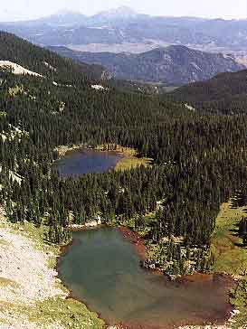
My new plan was to reach upper Winchell Lake, set up camp and then go up Blanca that afternoon or the next morning. Gary Roach in his new guide to the 14ers has a class 4 route to Blanca's ridge from this area. I can go for quite a ways on minimal water, but on this day I had put myself at a considerable handicap. I had just a couple of gulps of water in my bottle as I began the ascent of Lindsey, and now several hours later with no water source over this terrain I was feeling parched. Indeed I must admit that my progress slowed as I plunged across yet another boulder field below the saddle marking the push off point for an ascent of Blanca's Gash Ridge. Sam the Wolfdog despises boulder fields too, and I'm certain he was thirsty as well. Once across the boulder field an easy face was the next objective to climb up to the upper Winchell Lake at 12,700 feet. Before that we had an easy stretch across high grassy terrain interspersed with rocks.
At one point I was sure I had seen some large mammal dashing to the north only 30 feet away in my peripheral vision. Sam was unaware though, so I thought I must have imagined it. A couple of minutes later a lamb bighorn darted up almost directly on Sam before it realized its error and turned in terror running in the opposite direction. Sam of course was hot in pursuit despite my plaintive cries of "no". Shortly a herd of at least a dozen sheep were scampering across the boulder field, then up to the side of the rock face. I noted that they covered the same terrain it had taken me 30 minutes to laboriously conquer in a mere 60 seconds. Sam of course gave up after a mere 100 feet of pursuit.
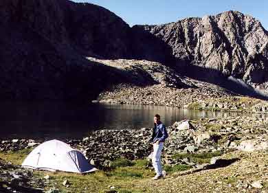
I then angled left towards a waterfall that eventually turned out to emerge from upper Winchell Lake. Mercifully, short of the actual waterfall we came on a gurgling stream and drank to our surfeit. Once up the easy face we were directly on the lake! I dropped my pack then and there and began scouting a good tent site. Skirting the lake along the east side I came on the ruins of a cabin. Noticing a few rusted out tin cans I set them aside to pack out when I left. After setting up my tent it was late enough in the day that I convinced myself to just chill out and wait to attempt Blanca the following morning. Well, chill out I did. As the sun dropped below the mountains it soon became quite cold.
Colder than I had clothes for, so it wasn't long after I had cooked up a memorable dinner of "Lucky seven vegetable Couscous" that I retired to the warmth of my tent and rather than my new 0F bag weighing 6 pounds, my TNF Tourlight 3D 35F bag. With extra clothes it is sufficient in sub-freezing temps, and weighing in less than two pounds has advantages. Prior to retiring I wandered a bit around the lake and found to my alarm hundreds of old rusted tin cans, old rusted saw blades, and other debris apparently left decades ago. I packed out some of it, but there is still a lot left. Winchell Lakes are seldom visited, and I am sure this trash is left over from long ago. It still is a blight on a pristine setting and I would like to make this request to those who may make it up to this area. Bring along an extra garbage tote and pack out what you can. Little by little we can return this lake to its original state.
 Next morning I awoke at 0400, and read from a novel I had brought along
just for this trip, Comanche Moon by Larry McMurtry. This was the fourth
and final volue of his excellent tetralogy of the western frontier.
Even if you hate the thought of "western novels" this series is a delight.
The ultimate "anti-western". After reading for an hour or so I dozed off
and didn't awake again until 0630. Sam had slept outside the tent all night
for the second night. He normally curls up at my feet. In this ultra-high
country there is not much mischieve that he can find, so it's just as well.
Next morning I awoke at 0400, and read from a novel I had brought along
just for this trip, Comanche Moon by Larry McMurtry. This was the fourth
and final volue of his excellent tetralogy of the western frontier.
Even if you hate the thought of "western novels" this series is a delight.
The ultimate "anti-western". After reading for an hour or so I dozed off
and didn't awake again until 0630. Sam had slept outside the tent all night
for the second night. He normally curls up at my feet. In this ultra-high
country there is not much mischieve that he can find, so it's just as well.
|
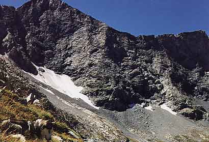
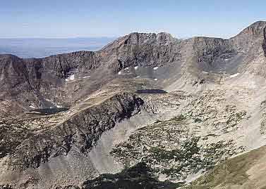
Ultimately I was on the mountain climbing agenda once again by 0730. First crossing grass-rock fields in the direction of the main ridge, Sam was on the team. Afterwards when faced with a considerable boulder field, to then be followed by the formidable face (ramp) leading to the ridge up Blanca, Sam decided he had had enough. He simply refused to continue. The boulder field was no more difficult than others he had already conquered. It must have been the prospect of the face beyond that made up his mind. He was not distressed when I continued across the boulder field, and at first I thought I could possibly make the climb while he simply awaited my return.
 A buttress pyramid separate from the actual ridge, but nearly as high,
obviously represented the "ramp" referred to by Roach. The question was
which side of the pyramid was the best course. I had spotted that pyramid
from the summit of Lindsey and thought the left side would be the ramp.
So this morning that is the tack I pursued. It was easy enough, all the
way to the top and level with the top of the "pyramid". The problem at this
point was gaining the actual ridge. An easy move across solid granite led
to what appeared to be a cake walk to the top of the ridge. I could have
done it 99 times out of a 100. I had forgotten my helmet though, and there
was the worry of the dog, and I was definitely alone, so I backed off, dropped
down the right ramp (so either way works) to an indifferent Sam. He obviously
was content to wait as long as it took. The wide open country held enough
intrigues for him to occupy himself.
A buttress pyramid separate from the actual ridge, but nearly as high,
obviously represented the "ramp" referred to by Roach. The question was
which side of the pyramid was the best course. I had spotted that pyramid
from the summit of Lindsey and thought the left side would be the ramp.
So this morning that is the tack I pursued. It was easy enough, all the
way to the top and level with the top of the "pyramid". The problem at this
point was gaining the actual ridge. An easy move across solid granite led
to what appeared to be a cake walk to the top of the ridge. I could have
done it 99 times out of a 100. I had forgotten my helmet though, and there
was the worry of the dog, and I was definitely alone, so I backed off, dropped
down the right ramp (so either way works) to an indifferent Sam. He obviously
was content to wait as long as it took. The wide open country held enough
intrigues for him to occupy himself. |
Returning to my tent site I first read for an hour out of Commanche Moon, then packed away my kit and began the retreat towards the "Gash" saddle. Lots of boulder fields the rest of the way. Dropping from the saddle it turned out the best course was to stay to the right (left as ascending from Huerfano). Less large boulders to contend with. At one point not far from the valley floor I stupidly dropped my pack over a short dropoff. My pack continued quite a ways farther than I had predicted, spilling out among other items my camera! Fortunately my trusty Canon AE-1 that has been true to me for 18 years held up. The valley floor was delightful as we rambled along the river in warm sunshine in the direction of the trailhead. At that point it seemed wise to save California Peak for another trip to this magical valley, so I would have reason to return.