Ascent of Little Bear
Peak
26 Sep 99
By Steve Bremner and Sam
the Wolfdog
I've been doing a little exploring lately. Okay, I won't quibble--trespassing.
When I read in a couple Colorado Mountain Guides that the easiest route
up Little Bear Peak had been closed because the property owners had denied
access this peaked my curiousity. September 12th was my first exploration
of Blanca Basin. At that time I climbed Blanca Peak.
and got lost four times. This time I knew my way.
|
First I'd like to pontificate a bit on trespassing. In Europe,
where I lived five years in the mid-80's, Germany to be specific, there is
a tradition of private property just as in the U.S. However, if private property
owners in Europe completely closed off their property to hikers and recreators,
given the much larger population burden they have, it would be a pretty dismal
place in which to live. After all the owners of the private property themselves
would be restricted only to their private property and would be unable to
experience the pleasures of the countryside in other parts. Therefore throughout
most of Europe it is completely legal to "wander" through farmlands
along dirt roads or country trails so long as one does not trample crops or
breach fences erected to contain cattle or domestic breeds. There are few
fences constructed as here in the U.S. simply to keep people out. I believe
after a couple of generations we will also evolve to this enlightened view
of property.
The "grant" that includes Blanca Basin is an atavistic
remnant of Spanish rule. I don't know this particular grant's history, but
another grant to the "Taylor Ranch" that includes the 14er Mount
Culebra (for which they now charge $40 a head for the "right" to
climb) was given to a 12-year-old boy and a sheriff and distiller of Taos
Lightening in the 1840's by the Spanish governor of Santa Fe simply beause
they asked for it. When both were killed by Indians the boy's father bought
out the sheriff's share for $100. We're talking about huge grants of land
including major mountains. I saw no evidence that anyone had set foot in Blanca
Basin for years.
As an opposite extreme to Europe there exists Hawaii. I lived
there for three years ('93 to '96). In Hawaii private property holders have
blocked access to public lands--national and state forests with prime hiking
terrain. It was there that I learned to simply go where my conscience led
me. To access the best trails you simply must trespass in Hawaii. My philosophy
is to always leave only my footprints and to pack out more than I bring in.
In other words whereever I go I pick up other people's trash, reasoning that
if enough people think like me we can manage to offset the garbage-strewing
cretins with whom we must coexist.
I must say at this point that there is a strong positive argument
for the owners of these grants blocking access to the general public. From
bears to coyotes to mountain lions, the wildlife of Colcrado has been harrassed,
intimidated, and driven from the best grounds by rampant development and increased
use of the backcountry by recreators. All intruders into the backcountry make
an impact on the existence and prosperity of these major mammals. Though recently
Rick Bass in his book The Lost Grizzly , provides evidence of the majestic
Grizzly's existence in Colorado, they have been mostly wiped out. Wolves in
the continental U.S. were once abundant. In a frenzy of slaughter in the mid
to late 1800's they were nearly all exterminated. Now this proud and dignified
animal is gradually being reintroduced in Yellowstone, Montana, and Arizona.
It is well that large blocks of land are being kept truly as wilderness.
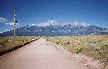
The most direct way up and into Blanca Basin is to turn right
on an unmarked dirt road, 400 yards after the Blanca township's City limits
sign (when approaching on US160 from the east). Further landmarks are a billboard
for Rio Grand Motel on the left hand side of the highway directly across from
the dirt road, and a sign for Blanca Peak maybe 100 feet prior. Drive directly
north on that dirt road until it comes to a T, jog right, then immediately
left on Oak Avenue. Continue on Oak Avenue until MM14th Street. Turn right
and proceed about half a mile or so. You will see a road to your left with
a "No Trespassing" sign on a piling and on your right away from
the road is an abandoned silver trailer. I believe, though I haven't verified
this, that the road with the "no trespassing" sign will take you
all the way to the trailhead. I continued further for a 100 yards, turned
up a rough 4-wheel drive road, then "stashed" my car off in the
scrub forest.
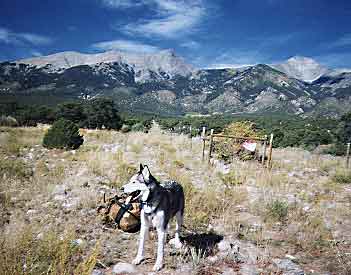 Now hiking directly north up the rough 4-wheel drive road you come to
a fence going at right angles--one side goes off to the east and the other
side goes north. Proceed north with the fence on your immediate right.
Continue for half an hour or so until there is a break in the fence where
a road goes to the right. It appeared a barbed wire detterent had been
snipped leaving the road open. On the left is a badly faded sign that
says "No T---".
Now hiking directly north up the rough 4-wheel drive road you come to
a fence going at right angles--one side goes off to the east and the other
side goes north. Proceed north with the fence on your immediate right.
Continue for half an hour or so until there is a break in the fence where
a road goes to the right. It appeared a barbed wire detterent had been
snipped leaving the road open. On the left is a badly faded sign that
says "No T---". |
 You follow that road to the right--there are fences on either side of
the road for a mile or two until a road merges from the right. Continue
another mile or so until the road runs directly into a fence. Do not cross
the fence. Instead go north alongside the fence until you reach the road
again 200 yards further along, where it once again comes to your side
of the fence. Now you are at the former trailhead to Blanca Basin. The
ruins of a cabin are off to the left in an aspen grove. As you move up
the valley to the north along a very faint 4-wheel track you cross a small
brook, then come on the ruins of a mine. This is where the trail to Blanca
Basin begins. It's not much of a trail at this point, and if you lose
it--not to worry. Just stay to the left of the dry gulch (the trail pretty
much stays about 25 feet to the left of the gulch) heading north. Your
goal is the ridge to the left, but it's easiest to go up the valley then
reach the ridge at its northernmost extreme. Once on the ridge you will
run into the trail--it's not the best trail, but cairns will keep you
on course. You follow that road to the right--there are fences on either side of
the road for a mile or two until a road merges from the right. Continue
another mile or so until the road runs directly into a fence. Do not cross
the fence. Instead go north alongside the fence until you reach the road
again 200 yards further along, where it once again comes to your side
of the fence. Now you are at the former trailhead to Blanca Basin. The
ruins of a cabin are off to the left in an aspen grove. As you move up
the valley to the north along a very faint 4-wheel track you cross a small
brook, then come on the ruins of a mine. This is where the trail to Blanca
Basin begins. It's not much of a trail at this point, and if you lose
it--not to worry. Just stay to the left of the dry gulch (the trail pretty
much stays about 25 feet to the left of the gulch) heading north. Your
goal is the ridge to the left, but it's easiest to go up the valley then
reach the ridge at its northernmost extreme. Once on the ridge you will
run into the trail--it's not the best trail, but cairns will keep you
on course. |
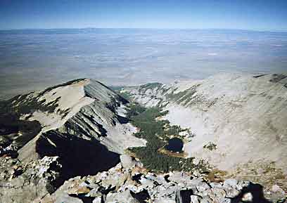
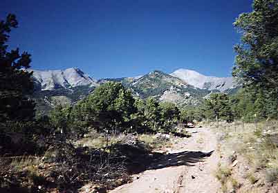
After reaching the ridge and leaving the valley, the trail climbs steeply
with Blanca Creek far below to your left. Levelling off a bit you reach
a nice patch of pine forest where on my Blanca climb of two weeks ago
I noted a bountiful crop of chanterelle mushrooms. On that trip I didn't
pick any. This time although much less of the delectable fruit of the
earth was evident, on my return the following day I managed to garner
enough to have a most tasty side dish of chanterelles sauteed with butter
and garlic with my dinner that evening. I'm still alive so they must
have been chanterelles!
Following the level patch of pine forest you soon come on an avalanche field,
where on my Blanca trip I sampled as many wild raspberries as I cared
to eat. This time there were some, but not enough to satisfy. Pick your
way through the deadfall and find the cairn on the opposite side after
maybe 75 yards or so.
|
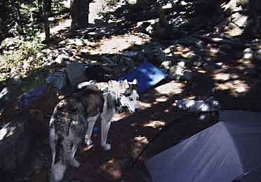
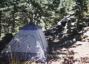 Eventually the trails brings you to a crossing of Blanca Creek. Pay
attention here, because it's easy to miss the crossing point. 50 feet
up the trail on the other side and to the left of the trail are the ruins
of a cabin. From my car to this point had taken me 2 hours and fifteen
minutes. I set up my tent next to the cabin around 6:30 P.M. The wind
was fairly strong and cold so I gave up easily on my attempts to build
a fire. When I left Colorado Springs In my typical packing rush I had
neglected to bring along dinner, so we would have to make due with a few
power bars and beef jerky for this trip. In the tent after dark I sipped
on the quarter full remains of a 750ml plastic "traveller's"
bottle of vodka and read the second issue of the new magazine from National
Geographic, Adventure. One feature article on the Queen Charlotte Islands
interested me. I had passed to their right on a trip up the Inside Passage
from Washington state to Alaska on a fishing boat in the 70's. This area
of the world is still very much wilderness and therefore very appealing
to me. Eventually the trails brings you to a crossing of Blanca Creek. Pay
attention here, because it's easy to miss the crossing point. 50 feet
up the trail on the other side and to the left of the trail are the ruins
of a cabin. From my car to this point had taken me 2 hours and fifteen
minutes. I set up my tent next to the cabin around 6:30 P.M. The wind
was fairly strong and cold so I gave up easily on my attempts to build
a fire. When I left Colorado Springs In my typical packing rush I had
neglected to bring along dinner, so we would have to make due with a few
power bars and beef jerky for this trip. In the tent after dark I sipped
on the quarter full remains of a 750ml plastic "traveller's"
bottle of vodka and read the second issue of the new magazine from National
Geographic, Adventure. One feature article on the Queen Charlotte Islands
interested me. I had passed to their right on a trip up the Inside Passage
from Washington state to Alaska on a fishing boat in the 70's. This area
of the world is still very much wilderness and therefore very appealing
to me. |
 Awake around 4 A.M. I organized my "kit" with leisure. Though
I didn't have "breakfast" I heard it once said that the secret
to a successful day lies in a leisurely breakfast. I had a leisurely morning, anyway.
I was on the trail
at 5:30 following the track up to Blanca Basin. After the trail stopped
climbing and started to level off I left the trail to begin ascending
to the left through steep timber, talus, and cliffy terrain. The harvest
moon was full and lit up my way. By the time the sun took over dominance
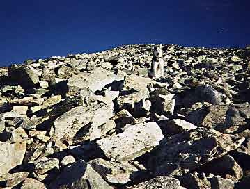
I was above the timberline. The ascent from here was on rotten talus.
Not difficult at all, but quite tedious. No rock was stable. Even the largest
rock could move, sending another in its wake to wreak havoc on your calve
or worse send you pitching to the ground. Sam the Wolfdog hates climbing
through talus. Finally we reached the east peak of Little Bear. Maybe
a quarter of a mile to the west was the actual summit. How to get there?
Awake around 4 A.M. I organized my "kit" with leisure. Though
I didn't have "breakfast" I heard it once said that the secret
to a successful day lies in a leisurely breakfast. I had a leisurely morning, anyway.
I was on the trail
at 5:30 following the track up to Blanca Basin. After the trail stopped
climbing and started to level off I left the trail to begin ascending
to the left through steep timber, talus, and cliffy terrain. The harvest
moon was full and lit up my way. By the time the sun took over dominance
I was above the timberline. The ascent from here was on rotten talus.
Not difficult at all, but quite tedious. No rock was stable. Even the largest
rock could move, sending another in its wake to wreak havoc on your calve
or worse send you pitching to the ground. Sam the Wolfdog hates climbing
through talus. Finally we reached the east peak of Little Bear. Maybe
a quarter of a mile to the west was the actual summit. How to get there? |
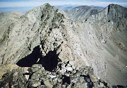 I started off on the right side of the ridge. This course was certainly
not inviting, even intimidating with a precipitous 2,000 foot plunge to
Blanca Basin the consequence of a slip. I treaded my way cautiously along,
Sam refusing to partake in this dangerous endeavour. Finally after a couple
tricky moves I lost heart and decided to turn around and give up on Little
Bear. After backtracking I had a look at the left side of the ridge and
quickly realized that this was the way. With minor difficulties even Sam
made his way to the true summit along this more gentle route. I started off on the right side of the ridge. This course was certainly
not inviting, even intimidating with a precipitous 2,000 foot plunge to
Blanca Basin the consequence of a slip. I treaded my way cautiously along,
Sam refusing to partake in this dangerous endeavour. Finally after a couple
tricky moves I lost heart and decided to turn around and give up on Little
Bear. After backtracking I had a look at the left side of the ridge and
quickly realized that this was the way. With minor difficulties even Sam
made his way to the true summit along this more gentle route. |
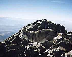
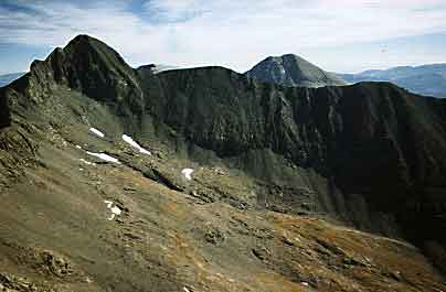 We summited around 9:00 A.M., three and half hours from our camp by
Blanca Creek.. It was windy and cold, but by ducking over the ridge we
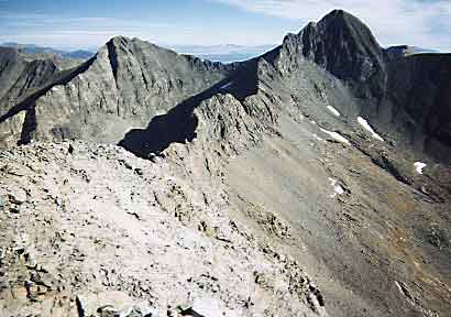
found shelter and enjoyed a vista including the Blanca Peaks, The Crestones,
Spanish Peaks, and even the ever present Pikes Peak far to the Northeast.
So proud of Sam for ascending this very difficult 14er I gave him an entire
6 oz. package of beef jerky for his reward. Truly a remarkable beast.
This was his 36th 14er. He has three additional ascents of Pike's Peak
to his credit as well. I will get him up Longs and Kit Carson later. I
know possible routes up those peaks that he can well manage. He is quite
the rock climbing wonder though! Wilson Peak, Wetterhorn Peak, and Crestone
Needle among his most glorious achievements.
We summited around 9:00 A.M., three and half hours from our camp by
Blanca Creek.. It was windy and cold, but by ducking over the ridge we
found shelter and enjoyed a vista including the Blanca Peaks, The Crestones,
Spanish Peaks, and even the ever present Pikes Peak far to the Northeast.
So proud of Sam for ascending this very difficult 14er I gave him an entire
6 oz. package of beef jerky for his reward. Truly a remarkable beast.
This was his 36th 14er. He has three additional ascents of Pike's Peak
to his credit as well. I will get him up Longs and Kit Carson later. I
know possible routes up those peaks that he can well manage. He is quite
the rock climbing wonder though! Wilson Peak, Wetterhorn Peak, and Crestone
Needle among his most glorious achievements. |
The return was simply a matter of making sure I intersected
the trail in the vicinity of my camp site, which proved easy enough. Along
the trail afterwards I collected enough chanterelles for my later feast. Back
to my vehicle around 3:30 P.M. I drove directly to Colorado Springs, home
before seven that evening.
fourteeners