Ascent of Mt Humboldt,
by Steve Bremner and Sam the Wolfdog,
on May 15th, 1999
Sangre de Christo Range,
Colorado
 After leaving work Friday afternoon I quickly gathered gear and dog for
the two-hour drive to the Sangre de Christo Range. It's a beautiful drive
SW of my home in Colorado Springs. South of Canon City Hiway 96 goes over
a lesser mountain range before dropping graciously into the historic towns
of Westcliffe and Silvercliffe at the foot of the towering Sangre de Christos.
After leaving work Friday afternoon I quickly gathered gear and dog for
the two-hour drive to the Sangre de Christo Range. It's a beautiful drive
SW of my home in Colorado Springs. South of Canon City Hiway 96 goes over
a lesser mountain range before dropping graciously into the historic towns
of Westcliffe and Silvercliffe at the foot of the towering Sangre de Christos.
The sun was just setting as I pulled into Westcliffe and the prospect
of a bivy in a cheap hotel was tempting. One hotel was full and the other
wanted $50 so I continued on towards the access road.
|
 The road leading to the trailhead for the South Colony
Lakes is a rough 4-wheel drive track in Summer--in mid-May it was impassable
beyond the National Forest boundary. I stopped well before that, set up
my tent, cooked up some spaghetti, and hit the sack early.
The road leading to the trailhead for the South Colony
Lakes is a rough 4-wheel drive track in Summer--in mid-May it was impassable
beyond the National Forest boundary. I stopped well before that, set up
my tent, cooked up some spaghetti, and hit the sack early.
|
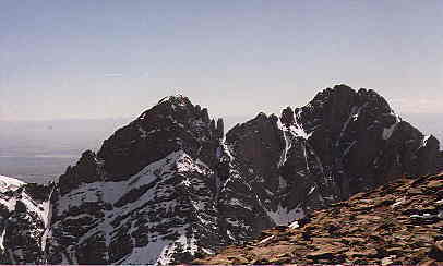
Low-slung rocky summits poking up in notch are Crestone Needle
(left) and Crestone Peak.
Large pyramid directly to their right is Humboldt.
 I had grandiose ambitions to climb Kit Carson and Humboldt that weekend.
I had no idea how much snow was up there when I decided to leave my snowshoes
in the car--postholing all the way to Kit Carson was not a pleasant prospect
and I settled for the easy one--Humboldt.
I had grandiose ambitions to climb Kit Carson and Humboldt that weekend.
I had no idea how much snow was up there when I decided to leave my snowshoes
in the car--postholing all the way to Kit Carson was not a pleasant prospect
and I settled for the easy one--Humboldt.
The road is 5.5 miles, followed by 2.25 miles to the lower South Colony
Lake. I set up a camp site close to the trailhead near the creek. It was
sunny when I set out for the summit around 1100 A.M. I aimed
for the lakes, keeping my eye on the saddle to the left of Humboldt. |
 There was so much snow, that I rarely saw the trail. The mountain was
obvious enough though, and after hiking up the basin just beyond the lower
lake I started up the wind-scoured side of Humboldt. The snow was not a
problem once on the mountain itself--the wind took care of that. There was so much snow, that I rarely saw the trail. The mountain was
obvious enough though, and after hiking up the basin just beyond the lower
lake I started up the wind-scoured side of Humboldt. The snow was not a
problem once on the mountain itself--the wind took care of that. |
 The view from the saddle of Humboldt looking west. Just over the
rocky ridge in the foreground is the "Bear's Playground"--a high flat area
at 13,000 feet. The high peak beyond that is "Obstruction Peak", elevation
13,799 and one of Colorado's bicentennial top 200 peaks. The rocky summit
just barely visible to the right of that is "Kat Carson" peak--part of
the Kit Carson Mountain massive.
The view from the saddle of Humboldt looking west. Just over the
rocky ridge in the foreground is the "Bear's Playground"--a high flat area
at 13,000 feet. The high peak beyond that is "Obstruction Peak", elevation
13,799 and one of Colorado's bicentennial top 200 peaks. The rocky summit
just barely visible to the right of that is "Kat Carson" peak--part of
the Kit Carson Mountain massive.
The route from here is either along the ridge all the way, or up from
South Colony Lakes to the Playground, then skirting Obstruction Peak to
the left, following obvious cairns. Then up and over Kat Carson Peak, dropping
500 feet before ascending a gulley to Kit Carson's summit. |
 Humboldt isn't a particularly hard climb--just a long slog up a pile
of gravel. The view of the Crestones from the summit is well worth the
effort, though!
Humboldt isn't a particularly hard climb--just a long slog up a pile
of gravel. The view of the Crestones from the summit is well worth the
effort, though!
On the way out I met a guy who had just soloed the Needle, which started
the seed for a July trip in which both I and Sam the Wolfdog would successfully
make the climb. |
 Sam the Wolfdog on top of Humboldt. Visible in the distance to the
right is a snow covered Pikes Peak. Sam the Wolfdog on top of Humboldt. Visible in the distance to the
right is a snow covered Pikes Peak.
Climbing fourteeners in winter/spring is a lot of work--from the longer
approach to the extra effort to move through snow. After this summit I
was content to head for home, leaving Kit Carson for another day.
(I climbed it on the 18th of July, 1999. Sam just missed the actual
summit, waiting on "Kat Carson" with a friend.) |
.
Back
to 14ers